Saturday, March 3, 2012

Jetties

For this post I'd like to talk a little about jetties.  A jetty is man made wall that is placed along the sides of an inlet.  The reason that jetties are installed are to prevent the inlet from shifting positions and to keep it open permanently.  Marinas along the East Coast of the United States are located in the protected bay, sheltered large waves during storms.  Jetties are constructed to make sure that the boats have permanent access to the ocean.  So the idea of jetties sounds great, right?  Well jetties have their down sides as well, which will be the topic of discussion for today.

The Indian River Inlet, DE (marinas.com)

Longshore Transport
Before we get into the nitty gritty of inlets, I want to go over ocean currents briefly.  Nearshore currents, for the most part, travel from north to south.  This has to do with the angle that the waves hit the beach.  These nearshore currents carry sand and other sediments down the coast.  This is a term called longshore transport.  Jetties are large stone walls that stick out into the ocean.  As the currents run into these walls, it loses energy and drops the sand that it was transporting down the coast.  On the updrift side of the jetty we get an accumulation of sand.  When the current passes by the inlet, it increases in energy and is able to pick up sand to transport.  This process causes erosion on the downdrift side of the jetty.

Diagram showing how longshore transport operates (crd.bc.ca)

Cape May
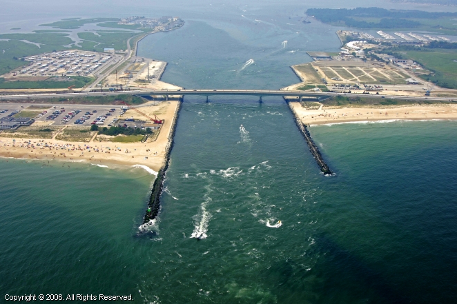
The Cape May Inlet jetty was constructed in 1911.  It separates the cities of Wildwood and Cape May, NJ.  Shortly after its construction, the Cape May Inlet jetty began causing erosion on the Cape May beaches (downdrift of the inlet).  You can see the amount of erosion along Cape May in the image below.  Note how you can determine the alongshore current direction by looking at the erosion associated with the inlet.  In this case the current is moving east to west.  Also notice how Wildwood (updrift of inlet) is accumulating sediment on its beaches.  The beaches along Wildwood are HUGE because of the jetty.
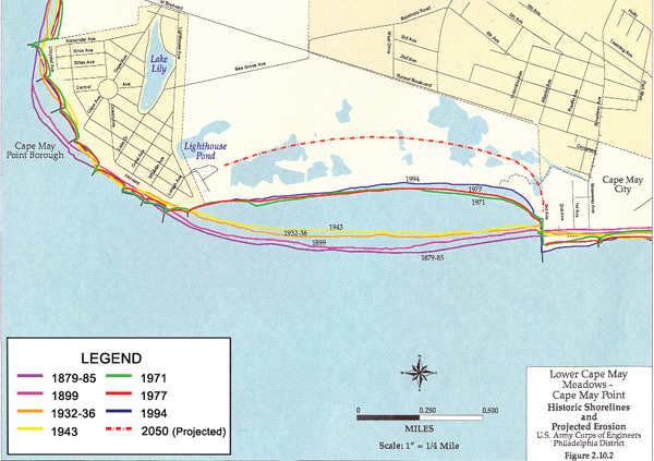
Erosion along the Cape May beach cause by the jetty construction in 1911 (Image: Karen Fox, Rebuilding a Beach)
Assateague Island
Assateague Island is the textbook example of erosion of a beach caused by a jetty construction.  In 1933, a hurricane came up the East Coast of the U.S. and caused an inlet to form just south of Ocean City, MD.  It was decided to keep the inlet open permanently by constructing a jetty.  Construction on the Ocean City Inlet was completed in 1935.  Ocean City is located on the updrift side of the inlet, while Assateague Island is located on the downdrift side.  Low and behold, Assateague Island started eroding away... big time.  Assateague Island is part of the National Park Service, so it is undeveloped and inhabited.  So much erosion took place on Assateague Island that the barrier island width actually thinned and began moving landward.  Today, Assateague Island has been somewhat stabilized by replenishing the beach occasionally.

The landward migration of Assateague Island, MD due to the Ocean City Inlet (Beaches and Coasts, 2004)

Final Word
So are jetties good are bad?  Well they're good in the sense that it stabilizes water traffic.  Both jettied mentioned in this discussion were stabilized for the use of adjacent Coast Guard stations.  The jetties are also used by fishing vessels.  Certain industries rely on the stability of inlets.  The down side of stabilizing inlets with jetties is that the downdrift beach will be eroded.  Inlets are very expensive structures to maintain because of the beach replenishment actions that must be taken on the downdrift side.

Thursday, February 23, 2012

Inlets

Welcome to the Geology Spot!
Welcome to the first post from the Geology Spot blog.  The goal of this blog is to discuss some scientific topics that I think are neat and break them down to a level that everyone can understand.  My name is Chris Seminack and I'm a Ph.D. student at George Mason University.  I specialize in coastal geology, in particular inlet geomorphology.  So I figured I'd kick off the blog with a posting about inlets.

Google Earth image of the barrier islands along the Maryland and Virginia coast

What is an inlet?
An inlet is basically a water-way that separates two barrier islands and connects the ocean to the bay.  A barrier island is essentially a really big sand bar that hugs the coast.  The Eastern United States has the longest chain of barrier islands in the world.  The only reason that inlets exist is because of tides.  Every 6 hours the tides change (high and low tide).  Think of the tides as the ocean swashing back and forth.  As the high tide rushes in, water flows through the inlets and into the bay.  Six hours later, the water that has collected in the bay from the high tide needs to get out.  The water in the bay then flows back through the inlet and into the ocean.  It is the tidal cycle that keeps the inlets open.  Inlets are essentially just passage ways so that the water in the ocean can flow into the bay.

Google Earth image of Drum Inlet, located in the Outer Banks of North Carolina

How do inlets form?
Inlets form as a result of severe storms like hurricanes or nor'easters (East Coast US terminology).  Storms are low pressure centers.  Because of the severe low pressure and winds from storms, the water beneath the storm tends to bulge up slightly (sometimes up to several meters for bad storms).  This is called a storm surge.  A storm surge forces a lot more water into the bay than what it is normally used to.  As a result, when it needs to get out, this water has no where to go except to spill over the barrier island, and thus, an inlet is born!

This picture was taken by the USGS immediately after Hurricane Irene along North Carolina.  The photo shows a large amount of erosion as a result of the hurricane.  A small temporary inlet was formed from the hurricane.


Why are inlets important?
Inlets are very important for many reason.  Certain marine animals depend on inlets to stay alive.  Water in the bay tends to be not as salty as ocean water.  This is known as brackish water.  Think of it as half way between fresh water and salt water.  Inlets control the salt levels in the bay.  If an inlet closes, the water may not be salty enough for the organisms living in the back bay.  And vice verse if a new inlet opens up.  An example of this occurred in the late 1800s along Assateague Island, MD.  The bay behind Assateague Island is known as Chincoteague Bay.  This bay was famous for its oyster farming.  Oysters tend to live in brackish water.  As a result of an inlet closing up along the island, the water in the bay became to fresh for the oysters and caused a die-off.  Inlets also bring in nutrients from the ocean into the bay.  Another example of why inlets are important is for boat owners.  If you've ever been on an ocean-going boat, chances are that you have traveled though an inlet.  Most marinas are located behind barrier islands because the waters are calmer and are protected from large storm waves.  Inlets act as a highway between the ocean and the bay.  Fish also use inlets in a similar way.  Many species of fish lay their eggs in the calmer, protected waters of the back bay.  They use inlets as a means to travel into the bay.

The Green Run Inlet along Assateague Island Maryland/Virginia before and after its closure.  This inlet caused the oyster die-off due to the bay water became too fresh.

Why do people study inlets?
People, like myself study inlets for many different reasons.  First, prehistoric inlets in the rock record have been known to hold oil.  Knowing how to look for barrier islands and inlets in the rock record is very valuable to petroleum geologists.  Another reason is to reduce property damage along the coast.  There are many million dollar homes along the beaches of the US and around the world.  Geologists can help reduce property damage by knowing how inlets form and where they are likely to form next.  Finally, studying inlets can help us learn more about the formation of barrier islands.  This is currently a very hot topic.  The ocean levels are rising at about 2 mm per year.  This may not sound like a lot, but it is.  At this rate, some of our barrier islands could literally be washed away in as little at 2000 years.  Studying inlets can teach us how the barrier island formed and how it reacted to sea level rise in the past.